Taking a look at SondeHub one evening in early July 2021, I noticed some radiosondes down in the Monterey Bay, about 75 miles south of San Francisco. There seemed to be one per day in the afternoon on most days. The Naval Postgraduate School launches radiosondes very infrequently for their meteorology program, but these seemed to be launched from Watsonville or Salinas, not the main NPS campus in downtown Monterey.
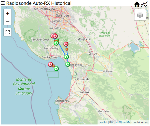
Then, on Monday July 12th, there was a flurry of radiosondes launched. I received a total of 5 of them from my station in Los Gatos. This station does not have good coverage in the direction of Monterey, and only starts receiving radiosondes when they rise up to 5,000 meters (~16k feet), above nearby mountains.
This rate of around 5 launches per day was sustained until Friday July 23rd. I was pretty busy with other things in life during this period, so I didn't really pay attention to these launches or landings.
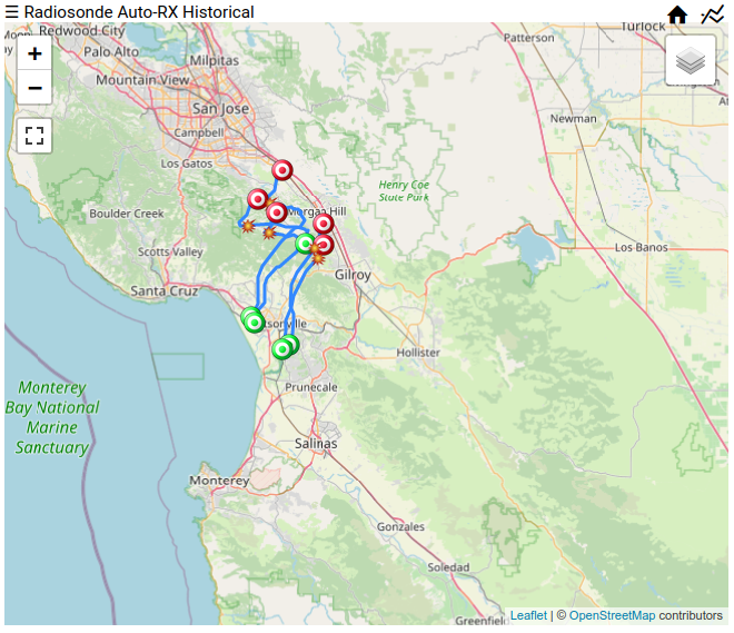
Then on August 20th, many radiosondes started appearing in the sky again, and this time I was ready. Most of these Monterey radiosondes were on 400.750 MHz, so I dedicated my Los Gatos station to receiving this frequency only. I started trying to figure out when they were launched, and what the launch location was.
Calculating Launch Times
As I mentioned previously, this receiver did not have good coverage towards the south, so the first packets received were above 5,000 meters depending on which direction the radiosonde was floating. Trying to calculate the launch time was the first piece of the puzzle.
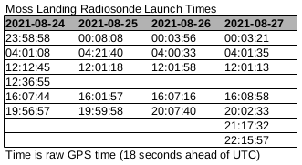
During my investigation of a superpressure balloon launched from Oakland, I realized that the ascent rate for radiosondes is pretty constant until the balloon pops. Averaging the ascent rate (which is one of the telemetry fields from a radiosonde) until max altitude, we can easily back out the launch time. Here is the calculations for the radiosondes launched on August 24th UTC:
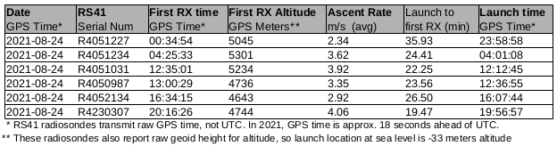
One of the very interesting things about this chart is the variable ascent rates. Regular radiosondes, such as those launched twice daily from Oakland Airport, ascend at ~5 meters/second until 30k meters, when they pop and fall back to the ground.
These Monterey sondes use smaller balloons, so they ascend a bit slower than the regular ones, and burst around 10k meters. But the variation in ascent rates, anywhere from 2.3 meters/sec up to 4 meters/sec, indicates that the balloons are manually filled, maybe for a set period of time or maybe until it "looks about full." Or maybe the people launching them want variable ascent rates?
One other thing to remember about radiosondes is that they use raw GPS telemetry for time and altitude. In 2021, raw GPS time is 18 seconds ahead of UTC, and here in the Bay Area the WGS84 geoid altitude is -33 meters above Mean Sea Level. So if the radiosonde is on the beach at 12 noon UTC, the telemetry will indicate 12:00:18 with an altitude of -33 meters.
Running these launch time calculations on all the balloons from August 24th until August 27th UTC shows a clear trend in launch times:
So the balloons are being launched every 4 hours, plus or minus a few minutes here and there, which is another indicator that these are hand launched. And no balloons are launched at 0800 UTC, which is 1am Pacific time. I like radiosondes, but who wants to stay up until 1am every day, then launch again at 5am? I need my beauty sleep.
Finding the Launch Location
So now I knew the timeline when the balloons would most likely be launched, the next piece of the puzzle is launch location. Looking at a map, it was a bit difficult to figure out where they were launching from. The lower level winds (below where I could receive the radiosondes) are variable, and I just didn't have enough data to calculate a launch location.
Using the winds from the Oakland radiosondes launched at approximately the same time indicated they were being launched from a ship in the ocean. I found this improbable, as there was no ships on AIS in the vicinity. Maybe it was a military or Coast Guard operation from ships that don't broadcast AIS?
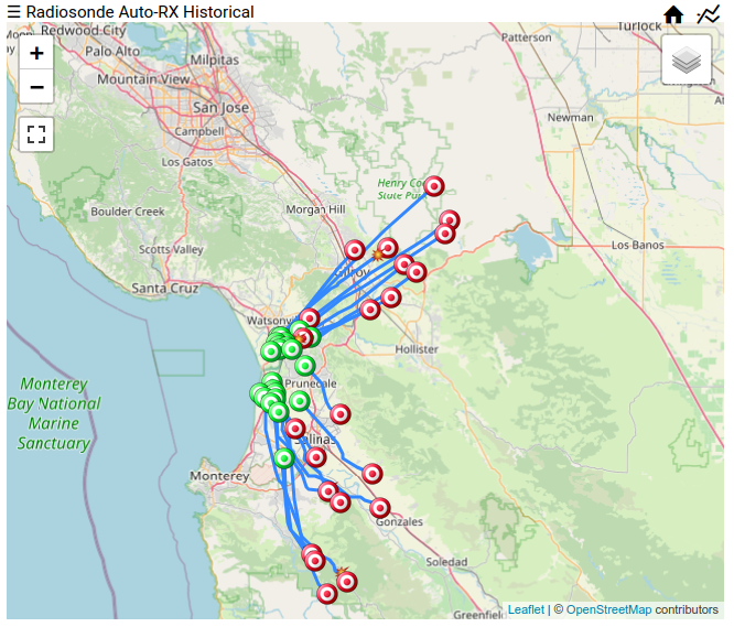
Zooming in on the radiosondes launched launched from August 24th to 27th (from the table above) shows the problem I was having.
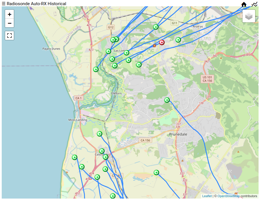
Maybe they are being launched from Pajaro Dunes? Or one of the many big warehouses along Highway 1? The Monterey Bay Aquarium Research Institute (MBARI) has a big research facility at the mouth of Elkhorn Slough, but most of their research is in the deep sea. Moss Landing Power Plant is nearby, but it was decommissioned in 2016 and I'm not sure why they would care about winds. Now there is a huge battery plant (pdf) there.
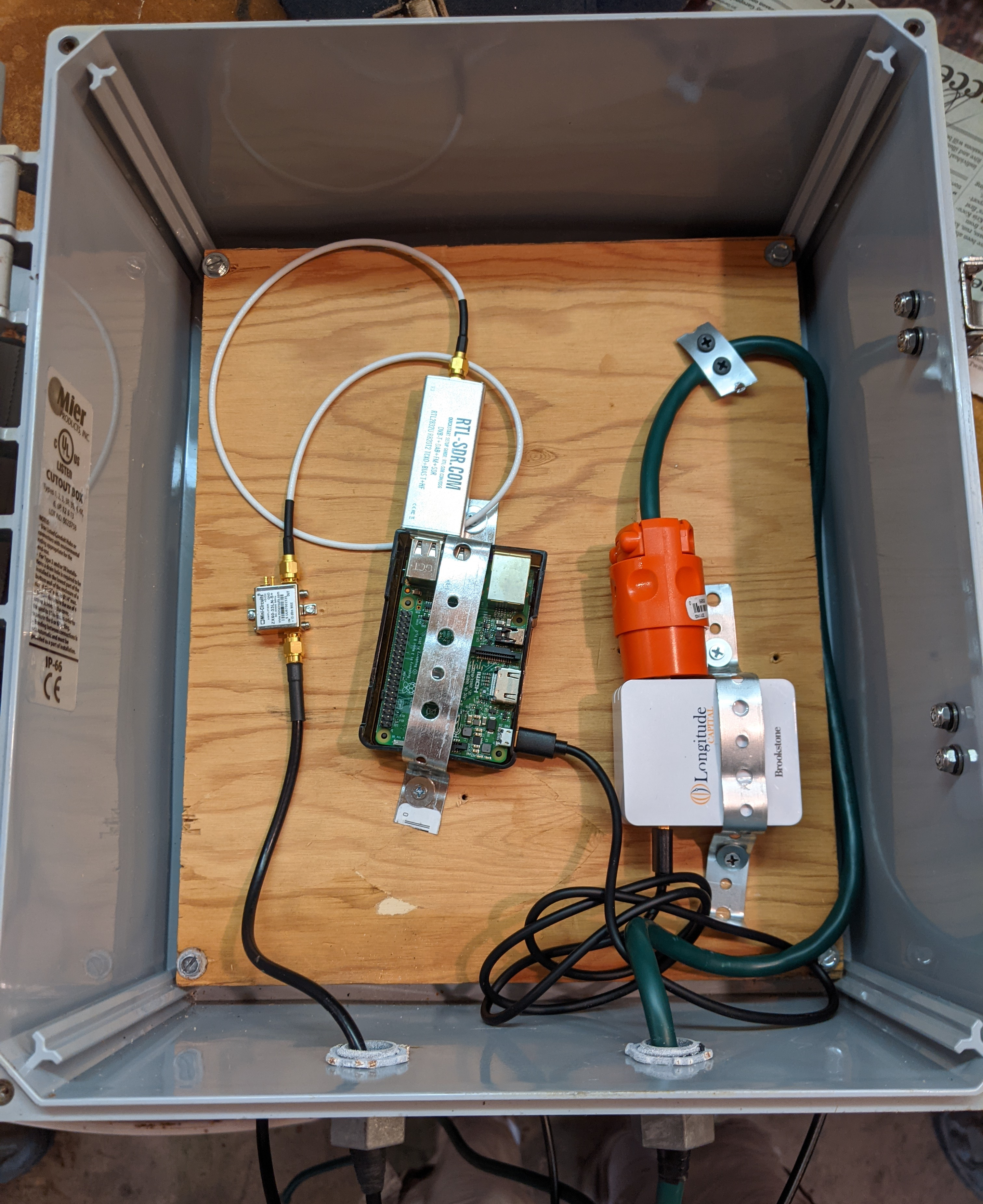
The only way to figure out the launch location, and who launching them, was to take a road trip. I decided to try and track the 2000 UTC launch (1pm Pacific time) on Sunday August 28th, hoping that this launch wasn't skipped or delayed too long. Here's my mobile setup that I use when trying to recover radiosondes:
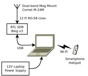
The software used to decode radiosondes is radiosonde_auto_rx, which can decode many different types of radiosondes. It also has a neat web interface, and the historical view is how many of the plots on this page were made. I run radiosonde_auto_rx in a docker container, which makes it super easy to install and update.
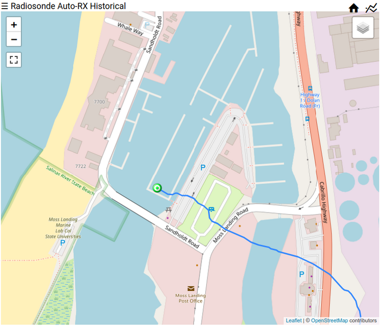
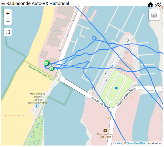
I parked on a small hill overlooking the area about 20 minutes before launch, and sure enough I started receiving the sonde right on time. The first packet I decoded was at 102 meters elevation (plus ~33 meters for the geoid difference). It was launched from Moss Landing, which most likely meant that it was MBARI that launched it, or maybe from a boat in the harbor. Zooming in on the first few packets, it appears to come from the first set of buildings on the left side of Sandholt Rd after crossing the bridge.
After watching the telemetry, I drove to the area and wandered around. Because it was a Sunday afternoon, all the gates were closed and it didn't look like anybody was around. I decided to take a stroll along the coast, maybe I could see something there.
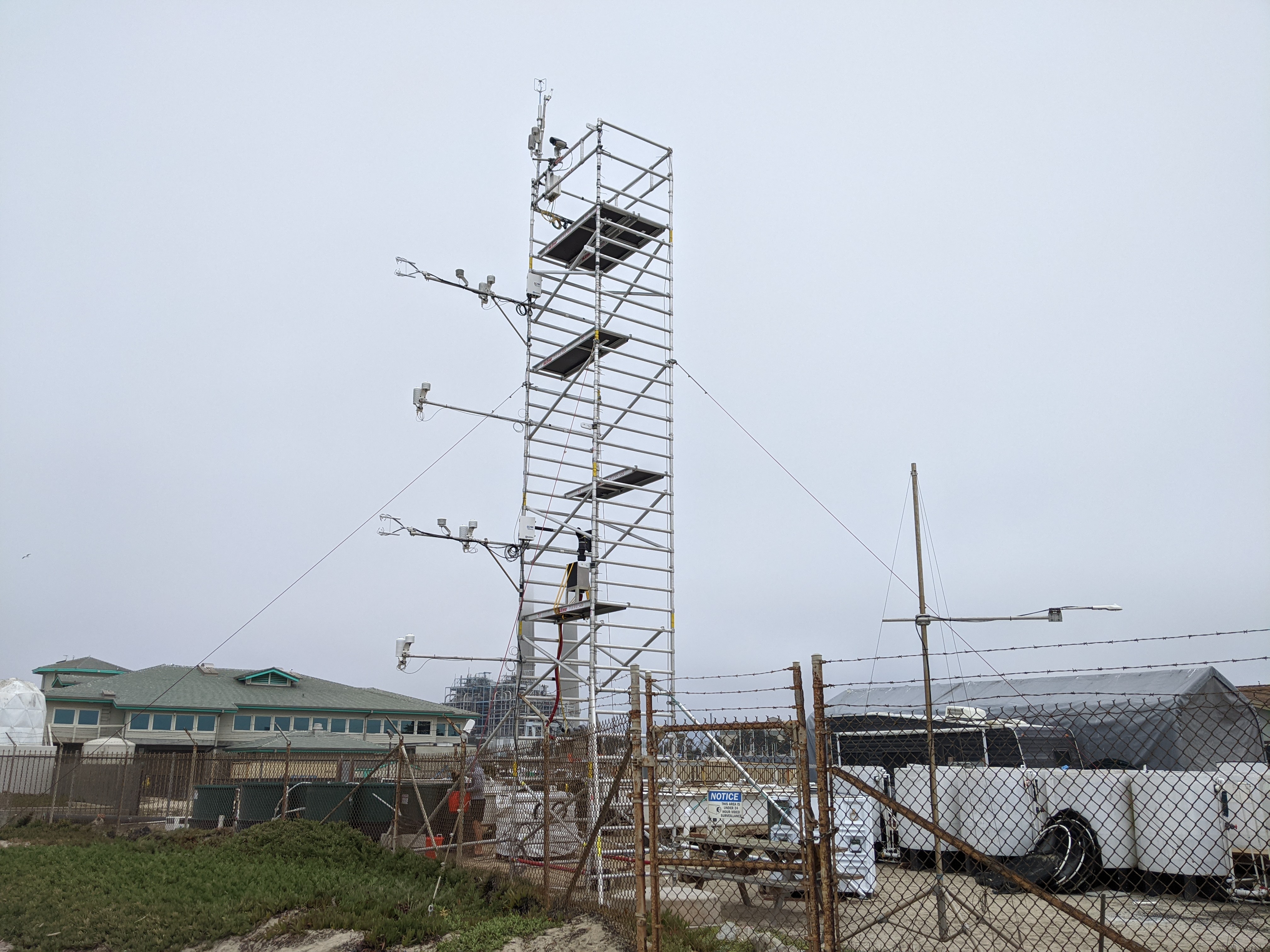
The first set of buildings I came upon was the San Jose State University Moss Landing Marine Laboratories Aquaculture facility. A grad student was collecting samples from a bunch of tanks of sea water, so I chatted with him thru the fence for a few minutes. Yes, the were launching radiosondes frequently, and the same project had built this huge tower with wind sensors every 6 ft. Bingo!
I got the name of the facility manager, and thanked him for the info. By this time, the radiosonde had landed in downtown Salinas, but I needed to get home so I left it for someone else to find.

After a few emails back and forth, I finally got in touch with the PI from the Naval Postgraduate School. They are doing some research on improving the forecast of waves and winds near the shore. Unfortunately, the intensive 5 sondes per day launch cadence was ending on September 2nd, but they are going to continue launching one radiosonde per day until October.
Santa Cruz Station
While my Los Gatos station has performed admirably for a year (and a few years prior to that as a SatNOGs station), the station's performance was trending down. When it rained, the station stopped receiving radiosondes completely, indicating that water was either getting into the antenna phasing network or into the coax, shorting things out. There was copious amounts of acidic bird crap on the antenna connectors and joints, which may be eating away at the plastic parts.
On a side note, this station was using Power over Ethernet (PoE) for powering the Raspberry Pi. I purchased a PoE splitter from Adafruit, but these devices spew large amounts of RFI. A standard HT receiver anywhere near the PoE splitter was completely overloaded with RF noise, so don't use these units for any RF receivers! I replaced it with a regular quiet AC-DC adapter.
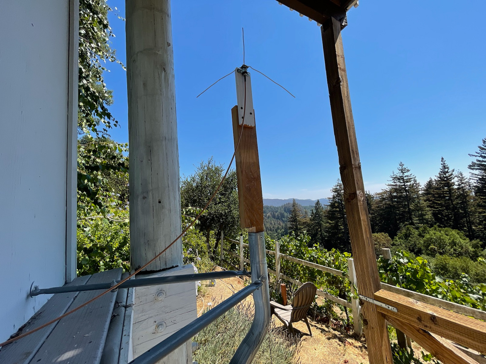
One of my old coworkers lives in the hills above Santa Cruz, with a clear view of the Monterey Bay. He agreed to host a station, so I pulled down the Los Gatos station, replaced the coax, antenna, and power supply, and installed it on Sept 6th. The smoke from nearby wildfires and marine layer has completely obscured the view of the ocean.
After some jamming from radiosondes down in Vandenberg, the first Monterey radiosondes I received from this new receiver all headed northwards towards San Jose, almost making it to populated areas. These sondes use smaller balloons that burst around 10k meters.
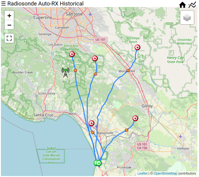
The new Santa Cruz receiver is on a hill about 575 meters (~1900 ft) above the bay, so it starts receiving the radiosondes as soon as they turn on. If you Zoom and Enhance on Moss Landing, you can almost see which side of the building they are released from! Although at this zoom level there seems to be registration/rectification issues between the maps and satellite images. It's also cool to see initial position and altitude telemetry, you can see the students walking around and the -30 to -40 meter altitude from the negative geoid height.
This station will be active at least until the end of September, when maybe I will move it back to Los Gatos, or find another old coworker who lives in an advantageous location. This receiver is high enough that it's receiving radiosondes down in Southern California, over 600 km away, which is pretty mind-blowing to me.