After the dissappointing results from the last balloon, we decided to respin the boards to try and fix this GPS self-interference problem. We also decided to add a low-pass filter to try and keep the WSPR transmitter harmonics out of the GPS band. The new boards did not arrive in time for the Memorial Day weekend, so we decided to launch anyways.
After a day delay due to strong winds and high altitude clouds, we launched on the morning of Sunday May 30th 2021. The weather was beautiful. The launch party was Martin W6MRR, Robert K6RGG, and myself KF6ZEO. We launched again from the northwest corner of the Berkeley Marina.
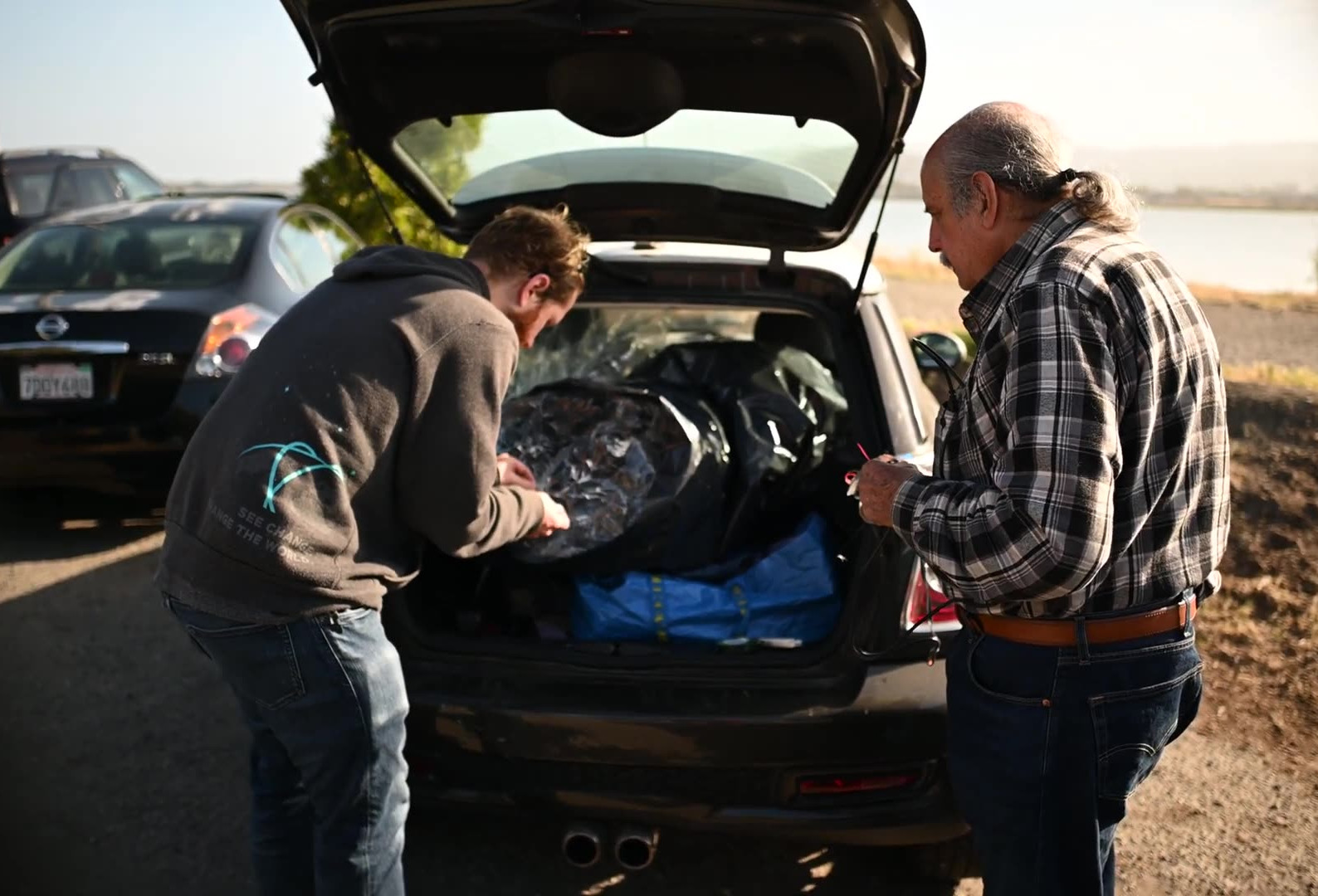
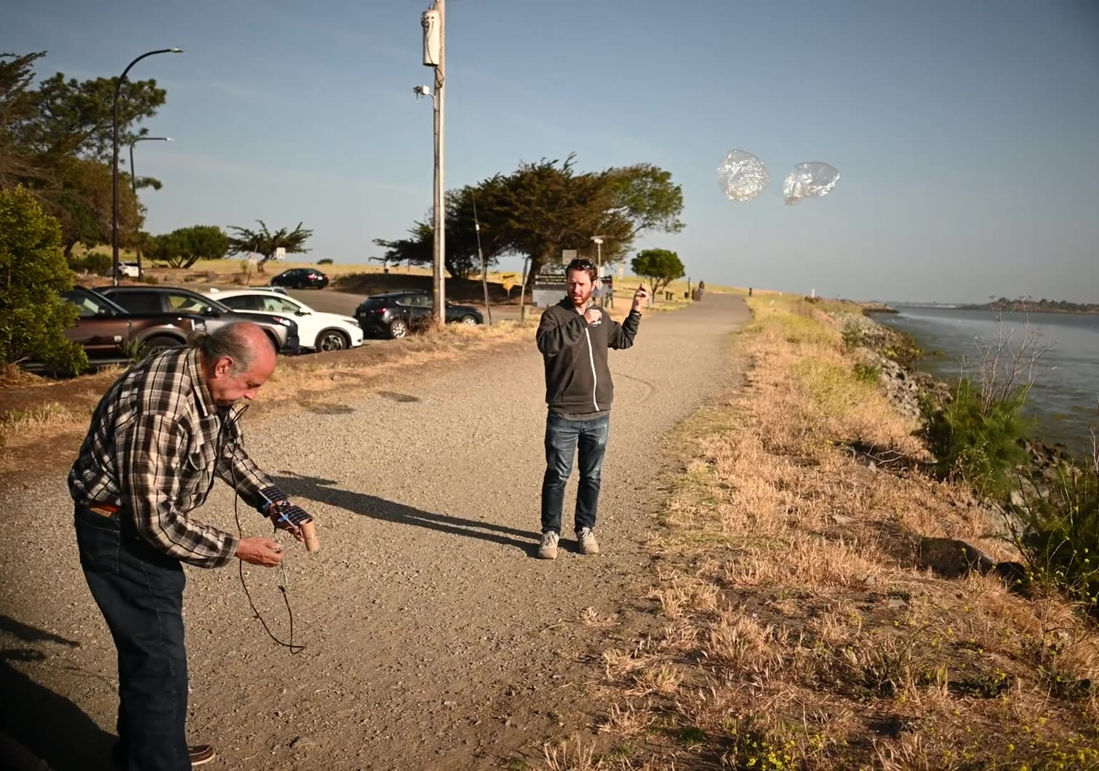
The winds were gusting to 5 knots or so, and we had to wait for a few minutes for a lull in the winds to release the picoballoon. Even a very slow wind can make the balloons bend over almost to the ground. We released the picoballoon just after 8 am local time (1500 UTC).
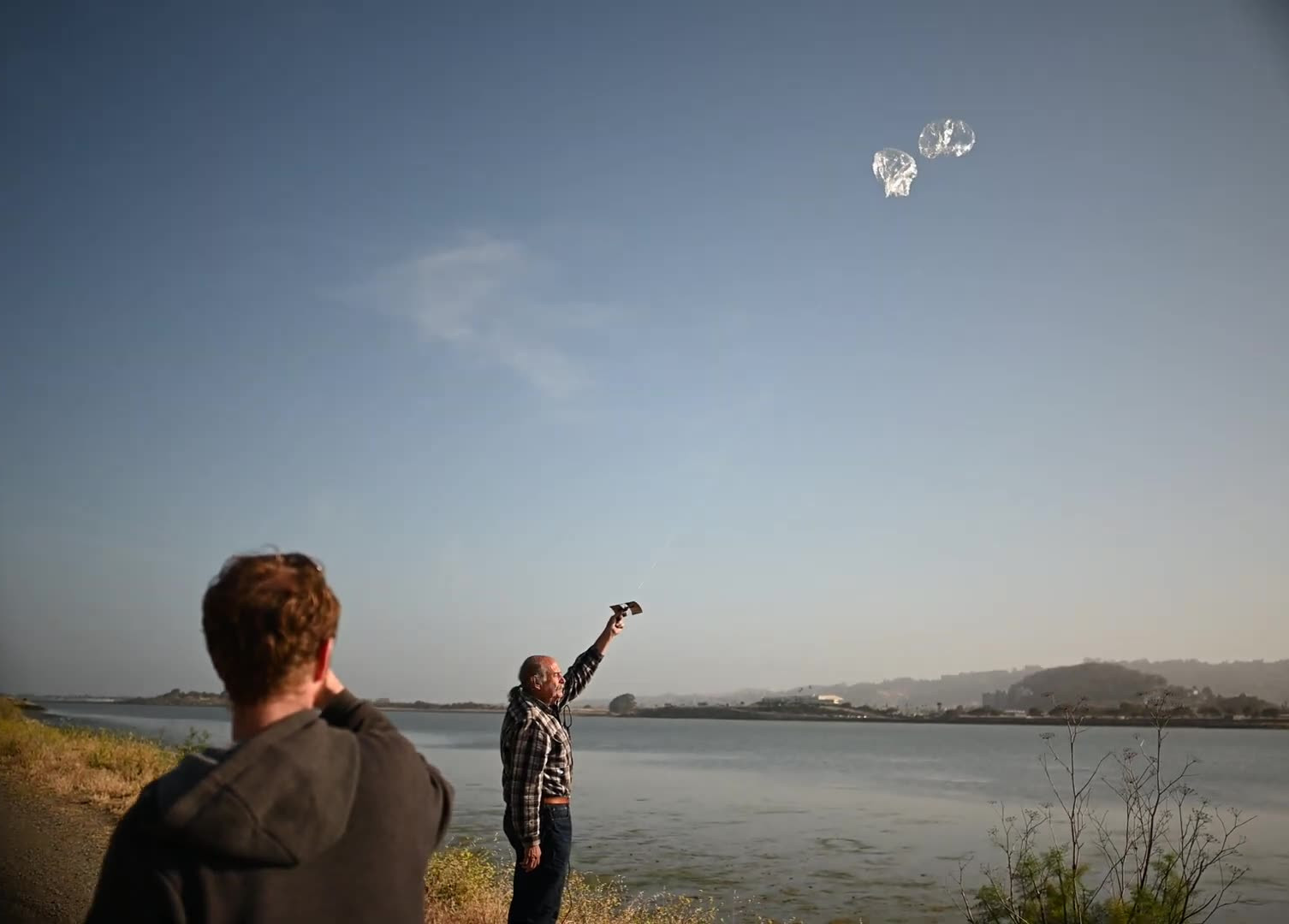
Robert K6RGG took a video of the preparation and launch sequence:
Just after launch, I ran some flight path predictions with NOAA HYSPLIT. These forward trajectory predictions showed that the balloon would head almost directly south for 30 hours, then float northwest for 54 hours over Mexico and the Mid-West before reaching the Atlantic Ocean around 0900 on June 3rd UTC.
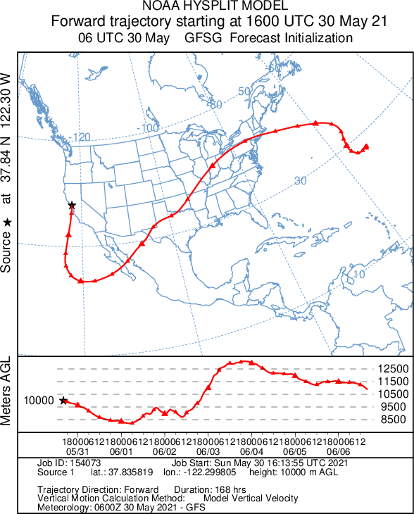
Every triangle on this forecast map is 6 hours, with the bigger triangles indicating midnight UTC. HYSPLIT uses the Global Forecasting System model, which is fed by radiosonde data.
Flight Data
This flight was somewhat successful. The tracker transmitted for two days. Nothing was heard on the third day, but on the fourth day one packet was received when it was on the ground. The WSPR callsign was W6MRR. Each green dot in the map below is a WSPR station that received the balloon
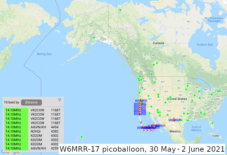
I used the aprsWsprBridge.py script to pipe this information into the APRS network. The APRS callsign for this balloon was W6MRR-17. Remember that for APRS, this script puts the marker in the lower left corner of the Maidenhead gridsquare, not the center.
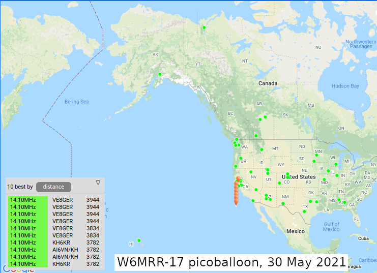
After launch, the tracker took about 45 minutes to power on, and we immediately started getting good data. The signal was much stronger than the previous picoballoon. It took 164 minutes to ascend from sea level up to 9900 meters (~32,400 ft), for an ascent rate of exactly 1 meter/second (198 feet/minute). This is a bit faster than the previous balloon's rate of 0.75 meters/second (~150 ft/min), but the final floating altitude was the same.
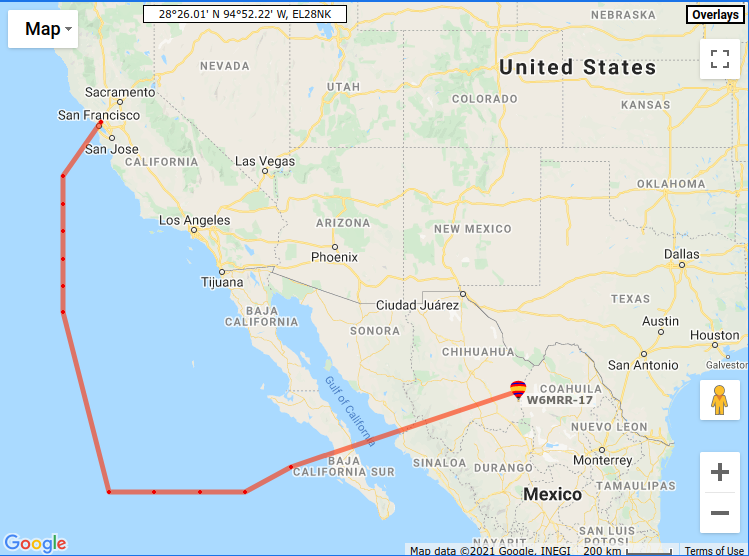
After launch the balloon headed straight south for 720 km (~450 miles) before sunset, for an average speed of 75 kph (~50 MPH). The tracker transmitted 120 beacons on this day, which is almost three times more transmitted packets than the previous launch had in total. This is a map from wspr.rocks showing the path of the balloon and the location of received WSPR packets on this day. The furthest station recieving the 10 mW beacon was Gerry VE8GER up in Inuvik, NWT, Canada, approximately 3944 km (~2450 miles) away. Wow!
Overnight it flew another 800 km (~500 mi) south, before waking up in gridsquare CL94, approximately 1,000 km (~620 miles) off the coast of Baja California.
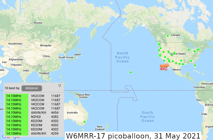
On Monday May 31st it flew all the way to the Baja California coast, transmitting at least 108 WSPR packets. The furthest station receiving our WSPR packets today was VK2COW outside of Canberra, Australia, about 11,687 km (~7,300 miles) away.
The balloon was not heard on Tuesday June 1st 2021.
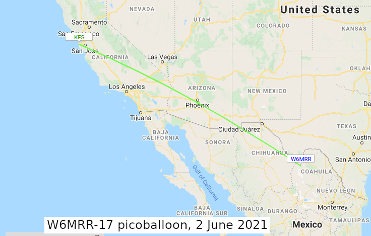
On Wednesday June 2nd, one packet was received by the amazing KFS WebSDR (PDF) located in Half Moon Bay, California. The balloon reported it was 900-2100 meters (~3,000 to 6,800 ft) in altitude, which probably means that it was on the ground. One balloon had probably burst and it had slowly descended, maybe even landing on a bush or tree. This area of Mexico is high desert, with an elevation of around 3,500 ft. This single packet was the last one received from this balloon ever.
Comparing our actual flight trajectory with the GFS forecast made just after launch, our actual flight path was pretty close to the prediction. While the balloon did follow the location pretty closely, the timing was a bit off. The balloon was flying directly east by around 1500 UTC on May 31st, but according to the model that should have happened around 0000 on June 1st, for a difference of about 9 hours.
The green lines in the map below show the actual flight path of the balloon, with the dashed lines where no actual flight data exists. Next launch, I will run predictions when the balloon turns off for the night. This should give us a much better next-day prediction of where the balloon should be.

While this picoballon was much more successful than our last launch, we still haven't reached our goal of floating around the world. We're planning on launching again soon, hopefully we'll reach our goal!
All of the WSPR data is saved in a spreadsheet here.